
Each year, the South Carolina Association of Regional Councils (SCARC) picks a “Regional Project of the Year.” Each COG is able to nominate one project for consideration by a state-wide panel. The nominees must represent a unique or innovative project or effort, undertaken by one or more SC COG, promoting a significant positive perception of any COG, all SC COGs or in implementing the concept of regionalism.
For 2011, Catawba Regional COG nominated the “Lancaster County Search and Rescue ‘STAR’ Team Tracking GIS Program.” This nomination was chosen by the SCARC Board of Directors as statewide “Regional Project of the Year.”
The project started in early 2010. During a search and rescue operation performed by the Lancaster County STAR (Specialized Tactics And Resources) Team it became apparent that a more efficient and effective method for tracking search teams in the field must be developed. The STAR Team is an interagency cooperative effort between the Lancaster County Emergency Management Division, Lancaster County EMS, Lancaster County Sheriff’s Office, Lancaster County Fire Service, City of Lancaster Police Department, and City of Lancaster Fire Department.
The creation of a new tracking method that allowed interactive accurate locations of teams to be electronically plotted was established as a goal. Catawba Regional Council of Governments GIS staff developed a GIS project that would run in “off the shelf” basic GIS software the county and city already was licensed to use and utilize nothing but freely available open source scripts and tools that would result in no additional expense to any local government.
In these lean economic times, an original approach that required no additional funding was necessary. In addition, the process of collectively finding a solution across agency lines served to strengthen those already strong relationships that existed between Lancaster County, the City of Lancaster, and the Catawba Regional Council of Governments.
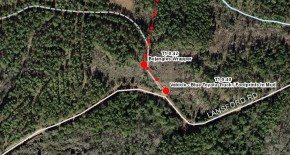
Through the tools developed it is now possible to accurately and quickly locate search team members in the field. The project automatically time stamps locations thereby creating a timeline of the search effort and includes the ability to add notations for such things as evidence found, victim locations, etc.. Additionally, it includes street centerline, jurisdiction, aerial imagery, and contour line base data for not only Lancaster County, but the surrounding counties as well. This is extremely helpful in multi-county search efforts.
Since implementation, the project has been steadily evolving and expanding. While the initial goals of the program were met, new and expanded goals have arisen as the project is utilized in the field. This includes expansion beyond its original intended use for such activities as evidence location logging by police and sheriff departments.
 (803) 327-9041
