
The Catawba Regional Council of Governments has developed a Geographic Information System (GIS) program to aid emergency response teams with search and rescue missions.
In the summer of 2010, the Catawba Regional Council of Governments was approached by Chief Chris Nunnery of the City of Lancaster Fire Department to develop a tool for the tracking of STAR (Specialized Tactics And Resources) Team members during search and rescue missions. The STAR Team is a cooperative between Lancaster County Emergency Management, City of Lancaster Police, City of Lancaster Fire, County Fire and Rescue, and the Lancaster County Sheriff. The STAR Team is activated and deployed when there is a missing person within the county; this can be a missing child, an Alzheimer’s patient, or even a fugitive.
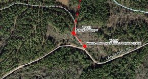
Prior to the GIS Search and Rescue Tracking Tool being launched in August, paper maps of the needed search area were plotted at the City of Lancaster Fire Department and brought to the STAR Team Mobile Command Center. These maps only included a single defined map coordinate grid system and covered only the initial search area.
There were several challenges when using the paper maps. First and foremost was that different departments utilize different coordinate grid systems on their handheld GPS units. This made tracking the locations of the teams very difficult due to the complicated conversions involved when moving from one coordinate system to another. Secondly, if the search moved to a location adjacent to the initial search area, a team member had to go back to the City of Lancaster Fire Department and print additional maps. The creation, printing, and delivery of additional maps typically would take in excess of an hour.
Catawba Regional developed a GIS based solution to interactively track the locations of rescue personnel and to allow immediate access to the county’s entire base mapping layers. There are several key components to the system:
• Tracking of up to 15 unique teams.
• Each team location is time stamped so that it is easy to rebuild the search scenario.
• Team location grid coordinates can be input in every standard map projection without having to manually convert.
• The tool has access to the entire GIS base map inventory for the county as well as surrounding counties.
• High resolution aerial imagery and USGS 1:24,000 topography maps are available for overlay.
• The ability to determine bearing and headings is included in order to easily reroute teams who must be deployed to new locations, such as a rescue point.
• On-the-fly maps may be exported to Adobe Acrobat .pdf’s or image .jpg’s which can be easily sent to rescue teams in the field via cellular networks.
• Unique projects and data files are created for every search deployment. This allows for search efficiency analysis and to serve as digital documentation of the search effort.
Since the launch of the tool, it has been utilized by law enforcement in Lancaster County for purposes well beyond the intended design. Most recently it was used to not only track teams in an area where human skeletal remains were found, but also document the locations of the evidence related to the recovery of the remains.
Catawba Regional is actively working with law enforcement in several member counties for the implementation of the tool region-wide.
 (803) 327-9041
